The first ever map of Shropshire up for sale
Elizabeth I was on the throne and Shakespeare was still a teenager when it was made, and now the first ever map of Shropshire is to go up for sale.
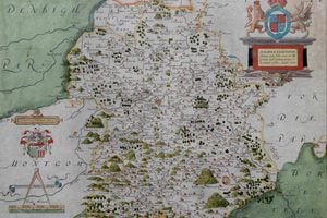
The Christopher Saxton map, drawn up in 1579, will be on display as part of an antique maps exhibition in the village of Brampton Bryan, on the Shropshire border between Leintwardine and Knighton – and could be yours for a cool £2,200.
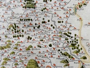
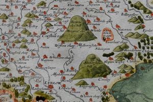
Despite being drawn up by tiny team rushing to cover every county in England in medieval times, the map is both surprisingly familiar and accurate, showing towns from "Whitchvrche" to "Wellynton", "Shrowesbvrye" to "Lvdlow" together with Shropshire's landmark hills.
It is one of many historical maps at The Marches: Maps, Prints and Bindings exhibition being held by Aardvark Books at Manor Farm.
Director Sheridan Swinson said the owner of most of the maps on display was a local collector and regular customer of his.
"He's a Ludlow bank manager, actually," he said. "He's put together an extremely large collection of Shropshire and Welsh maps over the years, but he's coming up to retirement and he's been gently selling some of his maps through me."
He said he had previously sold a Robert Baugh map from the beginning of the 19th century on behalf of the collector for £1,400.
"The Robert Baugh map is from 1808 and it is quite possibly the most important map of Shropshire. The reason for that is that it was made in the middle of the industrial revolution with everything going on in Shropshire.
"There are industrial sites on it that we only know about from that map."
But the 20 by 15-inch Saxton map was equally as exciting, Mr Swinson said. "This is the first time we have been able to show an original example of Saxton's first map of the county of Shropshire, it is a rare treat to be able to show it."
Mr Swinson added: "Altogether the exhibition offers a fascinating insight into the history and development of the Marches area, one of the most historic and beautiful areas of the British Isles."
The exhibition opens today from 11am, and every day until May 15.